Despite a mini-trip next month, we’re all a little preoccupied thinking about our next major adventure this summer: picking up where we left off in Seattle and driving all the way to Alaska. We got together last weekend to suss out the higher-level decisions.
Big Questions
- Where “in Alaska” are we going?
- Are we trying to drive to the Arctic Circle?
- Do we have a “the finish line” like Olympic National Park or the Grand Canyon?
- Do we want to run the entire AlCan Highway, or take the Cassair Highway for part of the drive? What about an epic ferry ride?
Where to?
This ended up being easy. For logistical reasons: flights, used car market, and friends in the area, we decided to end in Anchorage.
A “Finish Line” at the Arctic Ocean?
This would be so cool, but is not feasible within our timeline. If only we had a third week… We all want to do it one day, though.
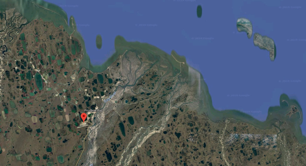
Prudhoe Bay, AK adds a 1,000 mile paved (mostly?) roundtrip from Fairbanks to a town that is not actually on the Arctic Ocean. Deadhorse is as close as you can get in a private vehicle. The oil companies that operate along the coast run a tour bus over the last five miles to the beach, which looks unremarkable except for its location.

Tuktoyaktuk, NT (Northern Territories) is a 1,700 mile unpaved roundtrip from Whitehorse, YT (Yukon Territory), but it looks pretty and there sure is a burger joint on the beach that you can drive to. All the pictures on their Google Maps entry are dust-covered SUVs and bikes on the beach; no one mentioned the food. There is a route over a mountain pass that cuts some of the return trip out, so the net add would “only” be 1,500 miles.
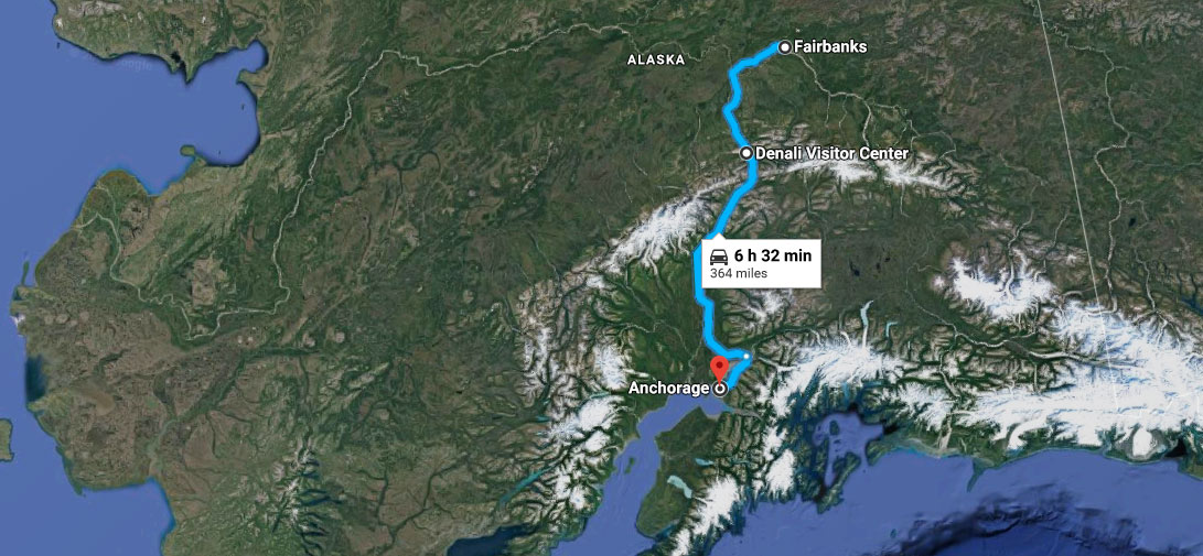
Denali National Park & Preserve is between Fairbanks and Anchorage. And for complicated “there aren’t many roads in Alaska” reasons, we actually come out ahead on distance if we drive to Fairbanks and cut down to Anchorage, assuming we want to see Denali. So we’ll make Denali the big finish line; that also answers “which major Alaskan city do we want to visit” with “both, duh.”
Routing Options
Spoiler alert: We’re still undecided about this.

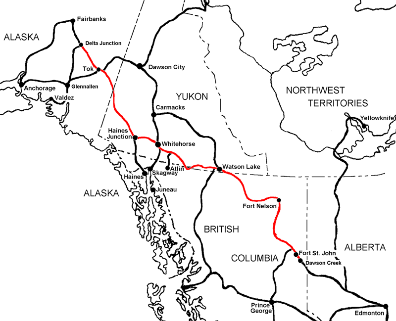
The AlCan Highway (Orange, 2600 miles)
The Alaska Highway was constructed during World War II to connect the lower 48 to Alaska across Canada, shortly after Pearl Harbor was bombed. Apparently there was concern that Alaska was at risk for invasion, and there was no way to get there by land from our side.
It begins at the junction of several highways in Dawson Creek, BC, and runs to Delta Junction, AK, southeast of Fairbanks. First completed in 1942, the highway opened to the public in 1948. Once legendary for being a rough, challenging drive, the highway is now paved over its entire length.
It is a stunning drive, and has also become very popular over the years. Many cities along its route have grown up with the increased tourism. We have several friends who have done it recently and by no means is it anything like our time in Big Sur, but we have gotten spoiled by remoteness.

Still, just searching for pictures of “AlCan Highway” on the internet will fill you with wonder. It is a historically and culturally significant journey, and if we stopped all our research now and said, “Let’s do it,” we would all be entirely pleased with our choice.
The Cassiar Highway (Green, 2500 miles)
The Cassiar Highway begins in Prince George, BC and joins with the AlCan Highway in Watson Lake. Looking at maps, it appears to spend much more of its route in the mountains and along waterways than AlCan proper before they meet up. It was originally constructed to connect the Cassiar Mining Company to the northern section of the AlCan before slowly being built out to the south. Cassiar Mining is now defunct and the town that shares the name is a ghost town, but the road and other settlements remain.

The Cassiar travels through a much less populated region, with fewer, smaller populated areas. That is decidedly more exciting than it is intimidating. But it is certainly both. It is apparently “almost” completely paved, but it is very rural.
The Prince Rupert Ferry / Cassiar Highway (Blue, 2550 miles)
On this route, we actually pick up where we left off by taking the Bainbridge Island Ferry out of Seattle back over toward Port Angeles and then riding the ferry to Victoria, BC like we’d wanted to on the first trip.
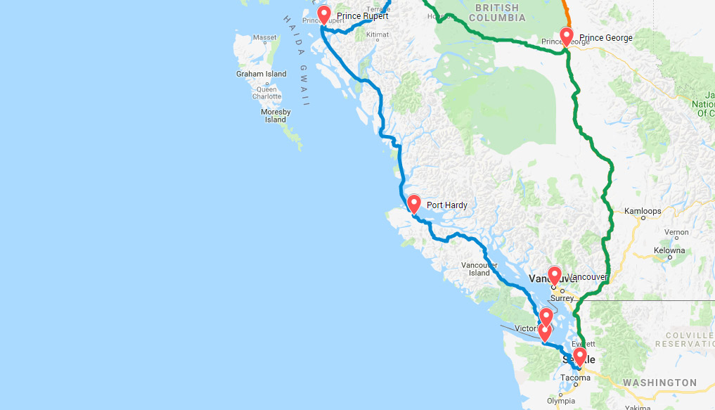
From Port Hardy on Vancouver Island, we catch the 18 hour ferry to Prince Rupert. And it’s not just a boat through nowhere — this ferry route weaves up a channel of islands! It runs from the end of the Johnstone Strait to just south of Alaska’s Inside Passage, but it doesn’t appear to have its own name.

From Prince Rupert, we drive inland, and join back up with the Cassiar Highway in Kitwanga, which seem to be where the best of Cassiar starts anyway.

Drawbacks: routing wise, it’s the highest stakes because the route calls for three ferries total and the Prince Rupert ferry only runs on odd-numbered days in August. If we miss it or have to bail back to the mainland, we’d backtrack more than full day. Also, in looking for that picture, I sure did find a few headlines that called into question the reliability of the schedule. Also it costs a million dollars.
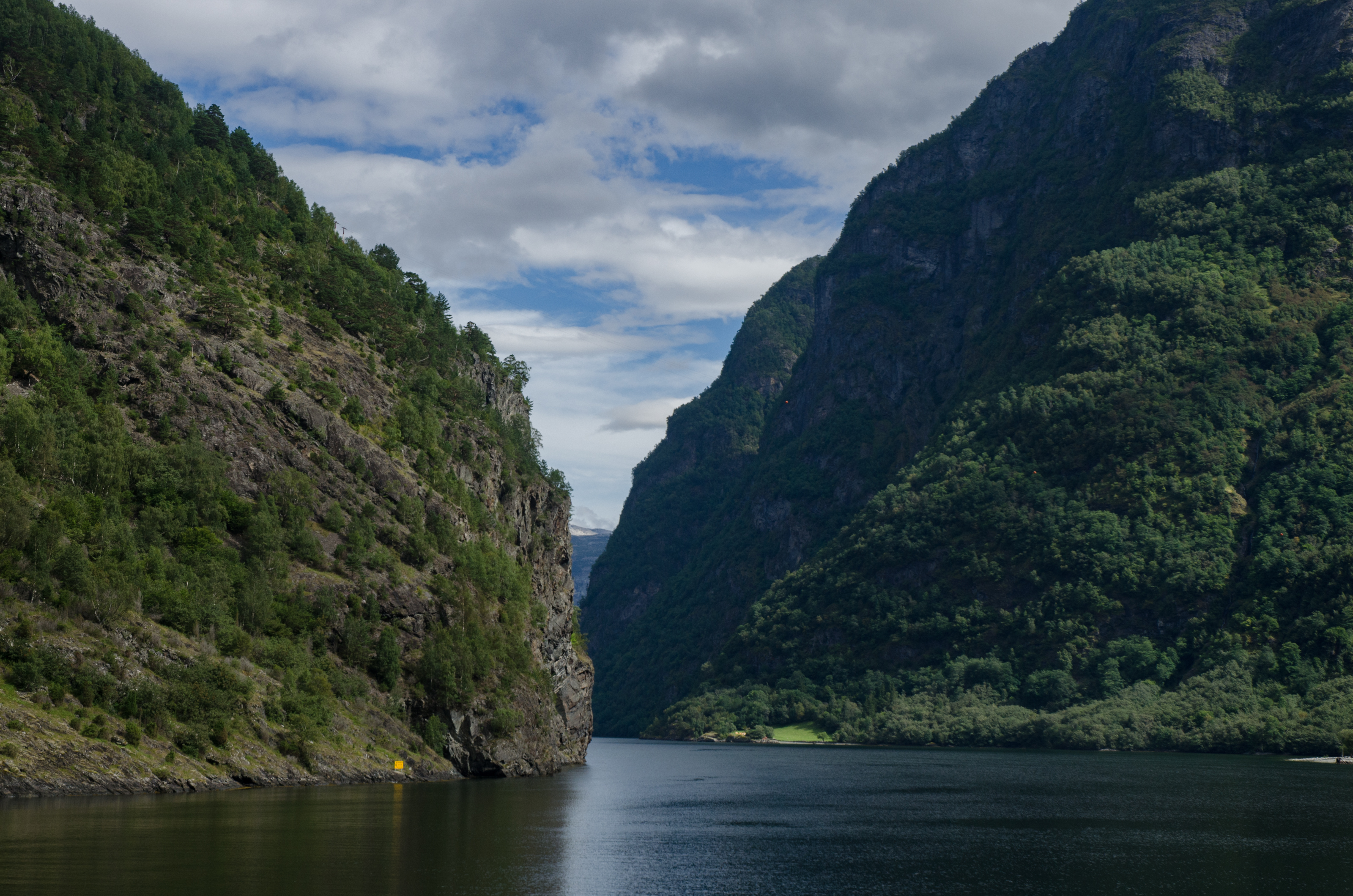
But as I think back on a long ferry ride I once took through Norway, I remember standing on the deck, totally entranced by the surroundings. What if this was even half what that was? I can’t help but ask, “How hard could it be?“
What Next?
https://oppositelock.kinja.com/some-serious-alcan-cheap-car-callenge-planning-was-done-1833593992 Kinja has deleted its OppositeLock and Overland communities. Content Unavailable
So we know Arctic Circle is out, and that we’re going to route through Fairbanks and Denali to end in Anchorage. We’re also leaning toward taking the Cassiar to AlCan at Watson Lake, having decided that we can live with the rebuke, “but y’all didn’t do the entire AlCan!!” The big choice left is if we take the ferries through the islands and start in Prince Rupert or stick to pavement the whole way. Naturally, George has ordered a book that he will read aloud, to help us get informed.